


Assisting urban planning by combining three-dimensional material and using gaming technology
The project tested a method combining point cloud data, 3D design material and a 3D model of Helsinki in the creation of the reference plan for land use in Vallisaari and Kuninkaansaari. Additionally, gaming technology offers new opportunities for urban planning.
What kind of problem did this project try to solve?
The project sought to answer the question of whether combining point cloud data, 3D design material and a 3D model of Helsinki could offer potential benefits when preparing land use plans, for example. At the same time, it examined the possibilities gaming technology offers in urban planning.
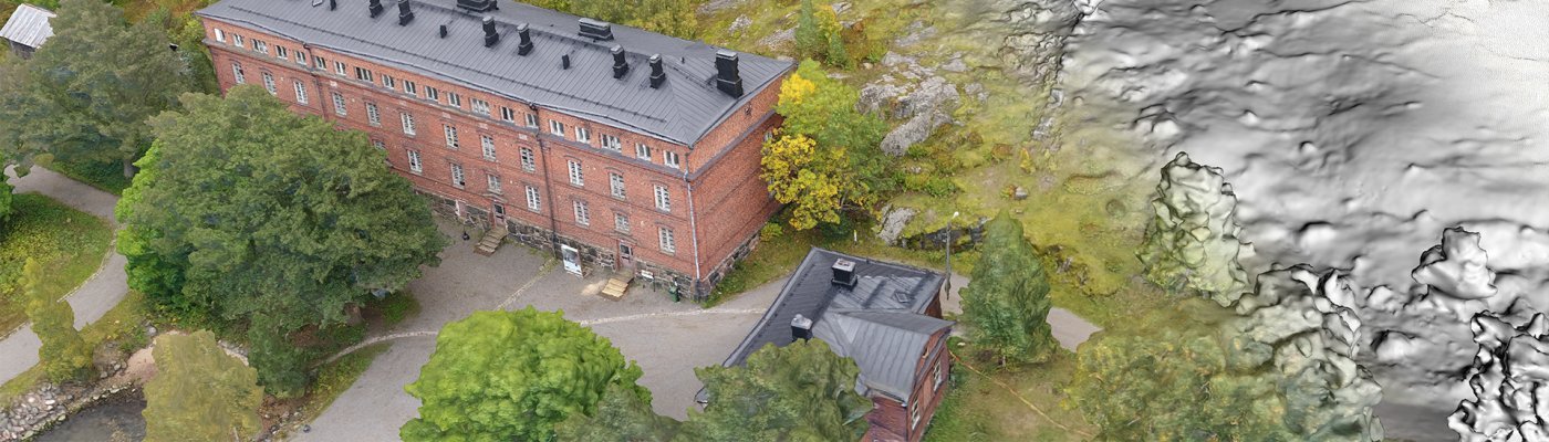
Point cloud data refers to a point cloud of an object formed by laser scanning – a three-dimensional model in which each laser beam represents one point. Laser scanning is a measurement method that provides precise, three-dimensional data on an object through the use of laser beams.
The experimental project combined point cloud data and 3D design material by utilising a 3D city model of Helsinki. Standardising this method could provide benefits in all design processes.
What was done in this project?
A reference plan project that assists land use planning on the islands of Vallisaari and Kuninkaansaari tested the combining of cloud point data, 3D design material and a 3D city model of Helsinki. More detail was added to the area being designed with photogrammetric imaging, and the resulting model was integrated into the broad Helsinki model. The 3D designs created in the reference planning were in turn sunk into the more detailed model.
Gaming technology served as a technical platform in the project, which investigated the possibilities offered by gamification. The potential and problems identified were described and reported with a view to developing the technology further in the future.
The project assessment was conducted by interviewing representatives of the City of Helsinki, as well as representatives of Metsähallitus, which owns the land.
Objective: to utilise a combination of 3D material and a 3D model of Helsinki and gaming in design
The main aim of the experiment was to standardise the procedure described above and the utilisation of the combination model it generates, in all design processes. Our testing sought to answer the following questions, among others:
Who benefits?
Urban planners, preparers of land use plans, actors in the construction and community planning sector, and businesses.
Combining point cloud data and 3D design data with a 3D model of the City of Helsinki
Duration: 10 October 2017–31 January 2018
Implemented by: WSP Finland
Partners: City of Helsinki, Metsähallitus
Contact information
